
Jody Colley Photography
Vol. 1 (2019 - 2020)

Vol. 1: Cover
White Sands National Park, NM
Great wave-like dunes of gypsum sand have engulfed 275 square miles of desert, creating the world's largest gypsum dunefield. White Sands National Park preserves a major portion of this unique dunefield, along with the plants and animals that live here.
Jody’s note: Unlike other sand dunes, the gypsum has a slightly heavier texture than sand, and what feels like moisture, which makes the dunes easier to traverse. The nearby Airforce base has a spectacular rocket exhibit on base—if you can get through security.
Map to General Area

Vol. 1: Pg. 3
Saint Teresa of Avila Church, Bodega, CA
Ansel Adams made the church the subject of a black and white photograph in 1953. The church is located directly next to the Bodega schoolhouse, which was the setting for the schoolhouse scene in Alfred Hitchcock's 1963 film, The Birds. The church was also seen in the film and Hitchcock attended services in the church.
Jody’s note: This photo was taken on Christmas day as parishioners were arriving to church. It was difficult to get a photo without arriving cars, people and greeters in the shot.
Map to General Area

Vol. 1: Pg. 4
Glory Hole, Lake Berryessa, CA
This is the 'The Glory Hole' at Lake Berryessa. Officially, its name is the 'Morning Glory Spillway,' as the hole is actually a unique spillway for the lake and Monticello Dam. When water levels rise above 440 feet, water starts spilling down the hole and into Putah Creek, hundreds of feet below.
Map to General Area

Vol. 1: Pg. 5
Arched Rock, Sonoma Coast State Park, CA
The property lies along State Route 1 and consists of a number of named beaches including Arched Rock Beach, Gleason Beach and Goat Rock Beach. The ecosystem consists of alternating sandy beaches and rocky shoreline, with a marine terrace extending above the entire extent with an upland California coastal prairie habitat.
Map to General Area
Vol. 1: Pg. 6
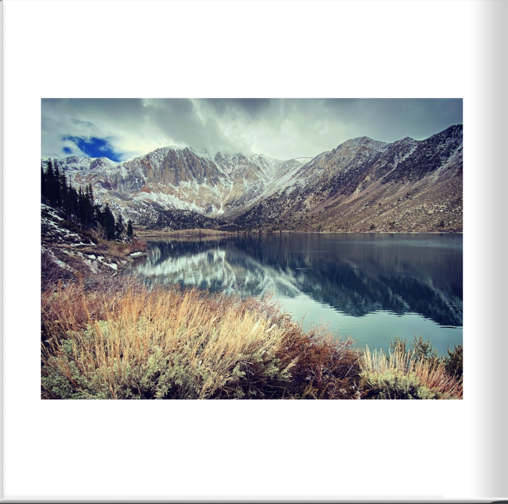
Convict Lake, CA
Convict Lake is a lake located in Mono County and is situated in the Sherwin Range of the Sierra Nevada mountains. It is known for its turquoise-blue water, the dramatic mountains (including Mount Morrison) that surround it, the trout fishing it affords, and its unusual history. The lake, known to the Paiute as Wit-sa-nap, was renamed by settlers after an incident on September 23, 1871, in which a group of convicts escaped from prison in Carson City, Nevada, and took refuge near the lake. They were pursued by a posse, and after it caught up to the convicts, a shootout followed, in which a number of both posse members and convicts were killed or wounded. The remaining convicts who survived initially escaped but were eventually captured and lynched.
Jody’s note: I love hiking around this lake. You’ll experience several microclimates along the way. On this day however, I didn’t get far before running into fresh bear tracks, so I backtracked and took photos near the parking area instead.

Vol. 1: Pg. 7
City of Rocks State Park, NM
City of Rocks gets its name from the incredible volcanic rock formations found here. The park encompasses a one square mile area in the scenic Chihuahuan desert region of southwestern New Mexico at an elevation of 5,200 feet. The “city” is a geologic formation made up of large, sculptured rock columns, or pinnacles, rising as high as 40 feet and separated by paths or lanes resembling city streets. These rocks were formed about 34.9 million years ago when a very large volcano erupted. Then, erosion over millions of years slowly formed the sculptured columns seen today, creating a stunning, otherworldly landscape.

Vol. 1: Pg. 8
Yellowstone National Park, WY
On March 1, 1872, Yellowstone became the first national park for all to enjoy the unique hydrothermal and geologic wonders. While the hydrothermal features of Yellowstone continue boiling, steaming, and erupting in winter, life within the park must adapt to the seasonal changes. Yellowstone is the only place in the United States where bison have lived continuously since prehistoric times. Yellowstone bison are exceptional because they comprise the nation’s largest bison population on public land and are among the few bison herds that have not been hybridized through interbreeding with cattle. Unlike most other herds, this population has thousands of individuals that are allowed to roam relatively freely over the expansive landscape of Yellowstone National Park and some nearby areas of Montana. They also exhibit wild behavior like their ancient ancestors, congregating during the breeding season to compete for mates, as well as migration and exploration that result in the use of new habitat areas. These behaviors have enabled the successful restoration of a population that was on the brink of extinction just over a century ago.
Map to General Area

Vol. 1: Pg. 9
Tucson Mountain Park, NM
Tucson Mountain Park was established April 1929. At approximately 20,000 acres, the park is one of the largest natural resource areas owned and managed by a local government in the U.S. The park has approximately 62 miles of non-motorized shared-use trials. The park’s trails are open to hikers, equestrians, and mountain bikers, and provide a wide range of outstanding experiences, including technical challenges, and breathtaking views. Gates Pass overlook includes interpretive displays and historic structures.
Map to General Area
Vol. 1: Pg. 10
Del Valle Regional Park, Livermore, CA
Deep in a valley framed by oak-covered hills, with sailboats and sailboards skimming over its waters, Del Valle is like a lakeside resort only 10 miles south of Livermore. The centerpiece of the park is a lake five miles long with a variety of water-oriented recreation, from swimming to windsurfing and boating, surrounded by 4,395 acres of beautiful land for hiking, horseback riding, and nature study. Del Valle also is the eastern gateway to the Ohlone Wilderness Trail, 28 miles of scenic back-country trail.
Jody’s note: One of my favorite Bay Area campgrounds, especially when the adjacent reservoir is full and the creek is flowing. Little did I know when taking this photo that Dexter was busy getting into poison oak, and later would give it to me.
Map to General Area

Vol. 1: Pg. 11
Moraine Park, Rocky Mountain National Park, CO
Excellent hands-on demo of how the Rockies were made. Turn the dials and make the land heave, crack and buckle. Watch glaciers move down the valley carrying rocks and debris making moraines and carving new lakes. Also, enjoy excellent exhibits of the animals that inhabit Moraine Park.
Jody’s note: The wildfires during my visit created significant smog, which helped to enhance this photo by making the mountain ridge outlines distinct. However, this was the clearest air day during my visit, which overall made taking good photos very challenging.
Map to General Area

Vol. 1: Pg. 12
Joshua Tree National Park, CA
Two distinct desert ecosystems, the Mojave and the Colorado, come together in Joshua Tree National Park. A fascinating variety of plants and animals make their homes in a land sculpted by strong winds and occasional torrents of rain. Dark night skies, a rich cultural history, and surreal geologic features add to the wonder of this vast wilderness in southern California.
Map to General Area

Vol. 1: Pg. 13
Lake McDonald, Glacier National Park, MT
Glacier Park's varied climate influences and its location at the headwaters of the Pacific, Atlantic and Hudson Bay drainages have given rise to an incredible variety of plants and animals. Both Glacier National Park and Waterton Lakes National Park, across the border in Canada, were designated International Biosphere Reserves and together were recognized in 1995 as a World Heritage Site. Glacier National Park is a 1,583-sq.-mile wilderness area in Montana's Rocky Mountains, with glacier-carved peaks and valleys running to the Canadian border. It's crossed by the mountainous Going-to-the-Sun Road which was used in the opening scene of the film, The Shining.
Map to General Area

Vol. 1: Pg. 14
Polebridge Mercantile & Bakery, Polebridge, MT
The Polebridge Mercantile, originally established by William and Jessie Adair, has been serving the North Fork community in remote Northwest Montana for over 100 years. Much as it has from the beginning, the “Merc” serves as a general store, bakery, base camp, and vacation getaway. It is one of the anchors of the North Fork experience and an essential stop for anyone visiting the west side of Glacier National Park. Some even know it as “The North Fork’s Last Best Outpost.”
Map to General Area

Vol. 1: Pg. 15
Lake Sabrina, Inyo National Forest, CA
Located in the Eastern Sierra Nevada mountain range, Lake Sabrina is high in the Inyo National Forest at an elevation of 9,138 feet and is outside Bishop, California. Lake Sabrina is created by damming the middle fork of Bishop Creek. The dam was built in 1907-8 to supply a constant flow of water to the hydraulic power plants.

Vol. 1: Pg. 16
Bucktown, CA
Bucktown is a farming and cattle community dotted with vineyards just north of Vacaville in Solono County, California.
Vol. 1: Pg. 17
Santa Rosa, CA
Santa Rosa (Spanish for 'Saint Rose') is a city and the county seat of Sonoma County, in the North Bay region of the Bay Area in California. With 176,753 people, Santa Rosa is the largest city in California's Wine Country and Redwood Coast, as well as the fifth most populous city in the Bay Area after San Jose, San Francisco, Oakland, and Fremont.

Vol. 1: Pg. 18
City of Rocks State Park, NM
City of Rocks gets its name from the incredible volcanic rock formations found here. The park encompasses a one square mile area in the scenic Chihuahuan desert region of southwestern New Mexico at an elevation of 5,200 feet. The “city” is a geologic formation made up of large, sculptured rock columns, or pinnacles, rising as high as 40 feet and separated by paths or lanes resembling city streets. These rocks were formed about 34.9 million years ago when a very large volcano erupted. Then, erosion over millions of years slowly formed the sculptured columns seen today, creating a stunning, otherworldly landscape.
Map to General Area

Vol. 1: Pg. 19
McArthur-Burney Falls Memorial State Park, CA
The park is within the Cascade Range and Modoc Plateau natural region, with forest and five miles of streamside and lake shoreline, including a portion of Lake Britton. The park's centerpiece is the 129-foot Burney Falls, which is not the highest or largest waterfall in the state, but possibly the most beautiful. Additional water comes from springs, joining to create a mist-filled basin. Burney Creek originates from the park's underground springs and flows to Lake Britton, getting larger along the way to the majestic falls. The park's landscape was created by volcanic activity as well as erosion from weather and streams. This volcanic region is surrounded by mountain peaks and is covered by black volcanic rock, or basalt. Created over a million years ago, the layered, porous basalt retains rainwater and snow melt, which forms a large underground reservoir. Within the park, the water emerges as springs at and above Burney Falls, where it flows at 100 million gallons every day. Burney Falls was named after pioneer settler Samuel Burney who lived in the area in the 1850s. The McArthurs were pioneer settlers who arrived in the late 1800s. Descendants were responsible for saving the waterfall and nearby land from development. They bought the property and gave it to the state as a gift in the 1920s.

Vol. 1: Pg. 20
Rainbow Falls, Mammoth, CA
Rainbow Falls is the highest waterfall on the Middle Fork of the San Joaquin River, in the eastern Sierra Nevada mountains of California. Plunging 101 feet to the turbulent water below, the falls are named for the rainbows that appear in their mist on sunny summer days. About 75,000 years ago, lava erupted from a vent just east of the present-day falls. The eruption occurred in two stages. The first pulse of lava flowed about 0.62 miles westward and pooled in the Middle Fork of the San Joaquin drainage. The second pulse of lava insulated the first, allowing it to cool slowly and to fracture vertically. The layer above cooled under different conditions and fractured horizontally. Geologists describe these rocks as platy rhyodacite; they are visible in the cliffs that surround Rainbow Falls. As water rushes over the cliff, it erodes the vertically fractured rhyodacite more easily. A small cavern begins to form at the base of the falls, and the overlying rock loses its support and collapses. This process, known as undercutting, causes the waterfall to recede slowly upstream. To date Rainbow Falls has retreated about 500 feet due to undercutting.
Jody’s note: This is a fantastic hiking trail which starts near Devil’s Postpile, crosses the Pacific Crest Trail, and leads to other trails throughout the Mammoth area. The entire area is spectacular to visit, weather permitting.
Map to General Area

Vol. 1: Pg. 21
Buffalo River, Island Park, ID
Fewer than a thousand animals a half a century ago, Idaho's moose are now estimated at 10,000 to 12,000 in population. The Buffalo River in Fremont County is 8.7 miles in length. It offers some of the most epic fly fishing of all the areas in Idaho you have to choose from. Rainbow and brook trout are plentiful. Just below Island Park Reservoir, where the Buffalo River joins the Henry’s Fork, there’s an easy place to fish where you’ll find why this junction is famous for huge rainbows. At an elevation of 6,200 feet, the region around the Buffalo River is as interesting as the river itself. Island Park was created from a volcano that collapsed thousands of years ago. Now the area is covered with pine forests and lots of gorgeous wildflowers and has become a mecca of outdoor recreation the year round.
Jody’s note: Moose are difficult to spot in the wild, and they are not friendly when approached. However, on this trip, I found fresh tracks by the Airstream on multiple mornings, and followed them to find the families nearby, where they love to eat the vegetation growing on the Buffalo River banks. When a few people would start to gather to watch them, they would cross the river.
Vol. 1: Pg. 22
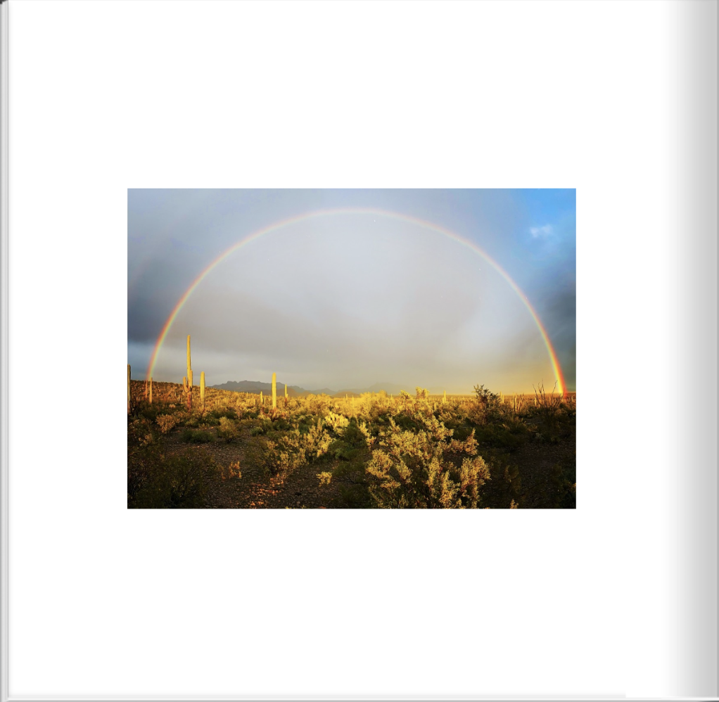
Ajo, AZ
Ajo is surrounded by 12 million acres of public and tribal land waiting to be explored. Organ Pipe Cactus National Monument and Cabeza Prieta National Wildlife Refuge offer expansive hiking, camping and birding places. The unpolluted skies have attracted countless astronomy buffs and stargazers. Peer through massive telescopes and enjoy educational programs and Native American exhibits at nearby Kitt Peak National Observatory. The area is home to more than 1,000 species of plants and animals, many unique to the area.
Map to General Area
Vol. 1: Pg. 23
Organ Pipe Cactus National Monument, AZ
Organ Pipe Cactus National Monument preserves over 330,000 acres of green, living desert that is yours to explore and get to know. Because of its amazing biodiversity, this place is considered a mecca for Sonoran Desert Research and is honored with a designation by UNESCO as an International Biosphere Reserve. Each of the plants have learned tricks and techniques to survive heat and drought, as well as freezing temperatures and floods. This is a land of extremes when it comes to plant life.
Map to General Area

Vol. 1: Pg. 24
Dinosaur National Monument, CO
Dinosaur National Monument is located on the southeast flank of the Uinta Mountains on the border between Colorado and Utah at the confluence of the Green and Yampa rivers. Although most of the monument area is in Moffat County, Colorado, the Dinosaur Quarry is located in Utah, north of the town of Jensen, Utah. The nearest Colorado town is Dinosaur while the nearest city is Vernal, Utah. The park contains over 800 paleontological sites and has fossils of dinosaurs including Allosaurus, Deinonychus, Abydosaurus, and various sauropods. The Abydosaurus consists of a nearly complete skull, the lower jaw, and first four neck vertebrae. The specimen was found at the base of the Mussentuchit Member of the Cedar Mountain Formation and is the holotype for the description. The area around the quarry was declared a national monument on October 4, 1915. The International Dark-Sky Association designated Dinosaur National Monument an International Dark Sky Park in April 2019.
Jody’s note: This is a very remote park. When I visited, I was towing the trailer, and there wasn’t a safe path for my overall vehicle length to drive into the valley to see the fossils or play in the Green River. I was limited to panoramic shots from the bluffs above. In the future, I will plan more time here and avoid the incredibly hot summer season.
Map to General Area

Vol. 1: Pg. 25
Glacier National Park, MT
Glacier Park's varied climate influences and its location at the headwaters of the Pacific, Atlantic and Hudson Bay drainages have given rise to an incredible variety of plants and animals. Both Glacier National Park and Waterton Lakes National Park, across the border in Canada, were designated International Biosphere Reserves and together were recognized in 1995 as a World Heritage Site. Glacier National Park is a 1,583-sq.-mile wilderness area in Montana's Rocky Mountains, with glacier-carved peaks and valleys running to the Canadian border. It's crossed by the mountainous Going-to-the-Sun Road which was used in the opening scene of the film, The Shining.
Map to General Area
Vol. 1: Pg. 26
Organ Pipe Cactus National Monument, AZ
Organ Pipe Cactus National Monument preserves over 330,000 acres of green, living desert that is yours to explore and get to know. Because of its amazing biodiversity, this place is considered a mecca for Sonoran Desert Research and is honored with a designation by UNESCO as an International Biosphere Reserve. Each of the plants have learned tricks and techniques to survive heat and drought, as well as freezing temperatures and floods. This is a land of extremes when it comes to plant life.
Map to General Area
Vol. 1: Pg. 27
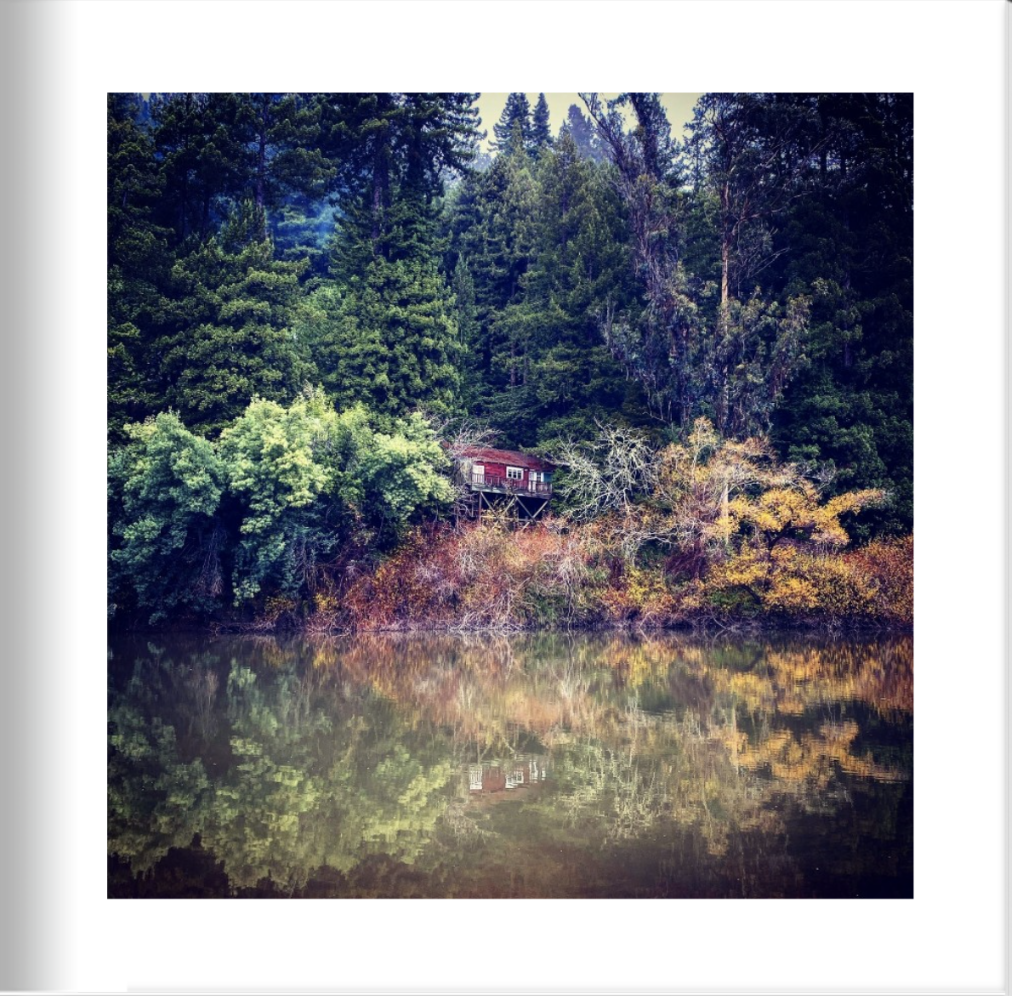
Monte Rio, CA
Along the banks of Sonoma County's Russian River, the hamlet of Monte Rio (pop. 1,152) knows how to roll out the welcome mat with flair. Tourists flocked by train starting in the 1870s, then came by the thousands in the 1930s and ’40s to hear Big Bands play in the town's outdoor pavilions. Today, a historic 1950s-style neon sign arches overhead, proclaiming "Welcome to Monte Rio Vacation Wonderland." Located on the north end of the 10-mile scenic stretch known as the Bohemian Highway, this little burg spreads out on both sides of the river. That slogan still rings true for those who want to enjoy splashing or paddling on the river, taking in fabulous views, visiting nearby world-class wineries, enjoying local theater, biking along winding roads lined with redwoods, fishing, hiking, or having picnics on a sandy river beach. It's home to the Monte Rio Amphitheater, an outdoor showcase for concerts, theater under the stars, and other events.
Map to General Area

Vol. 1: Pg. 28
Dexter, OR
With over 1.6 million acres, the Willamette National Forest is home to eight wilderness areas, including the popular Three Sisters Wilderness and Mt. Jefferson Wilderness, a variety of backpacking and day hiking opportunities, waterfalls, wildflowers, mountain biking trails, boating, swimming and much more. The varied landscape of high mountains, narrow canyons, cascading streams, and wooded slopes offers excellent opportunities for visitors and make the forest valuable for many purposes. Highway 68 connects Chemult with Eugene, and passes Odell Lake, Hills Creek Lake, Lookout Point Lake and Dexter Lake. A post office was established in Dexter in 1872 and named "Butte Disappointment" after a local landmark named in 1848. The post office was renamed "Dexter" in 1875, apparently after the "Dexter" brand cook stove owned by the postmaster's family.
Map to General Area

Vol. 1: Pg. 29
Old Mesilla, NM
The heart of the picturesque village of Mesilla is much the same as it was one hundred years ago. Thick walled adobe buildings, which once protected residents against Apache attacks, now house art galleries, restaurants, museums and gift shops. Today, tourists stroll on the peaceful plaza and imagine life as it might have been many years ago. Mesilla's most notorious resident, Billy the Kid, was sentenced to death at the county courthouse, but escaped before the sentence was carried out. Legendary hero Pat Garrett eventually tracked down and killed the Kid; later, Garrett was mysteriously murdered in an arroyo just outside of Las Cruces. He is buried in a local cemetery.
Map to General Area

Vol. 1: Pg. 30
Old Tucson, NM
The setting for many favorite Western movies (including Tombstone, Gunfight at the OK Corral, The Three Amigos, and countless John Wayne flicks), the Old Tucson Movie Studio had become something of a cinematic legend. Though a fire destroyed the studio in 1995, it has been carefully restored. Guests are treated to great views of the Tucson Mountains and the Sonoran Dessert. Attractions have been expanded to include pony rides, carnival games, stagecoach tours, gunfights, exhibits and an Opera House featuring live performances. Shopping and dining are plentiful at this unique attraction that offers a nostalgic glimpse of the Old West.
Map to General Area

Vol. 1: Pg. 31
Sand Harbor State Park, Lake Tahoe, NV
The largest alpine lake in North America, Lake Tahoe is a cobalt blue lake atop the Sierra Nevada mountain range. On its eastern shores, gently sloping beaches, crystal-clear water and interesting rock formations allow for wonderfully sublime swimming, kayaking and scuba diving at Sand Harbor. Boaters, water-skiers and fisherman can easily launch from one of the park’s two ramps. Visitors who would like a peaceful retreat from surf and sun can picnic in the shade of cedars and Jeffrey pines in one of many picnic sites equipped with barbecues and tables. The park also hosts the Lake Tahoe Shakespeare Festival every summer.
Jody’s note: Probably the most beautiful beach in Lake Tahoe, but I seldom spend much time because dogs are not allowed here. There are trails, rock climbing, and this is the perfect place to kayak or SUP.
Map to General Area
Vol. 1: Pg. 32
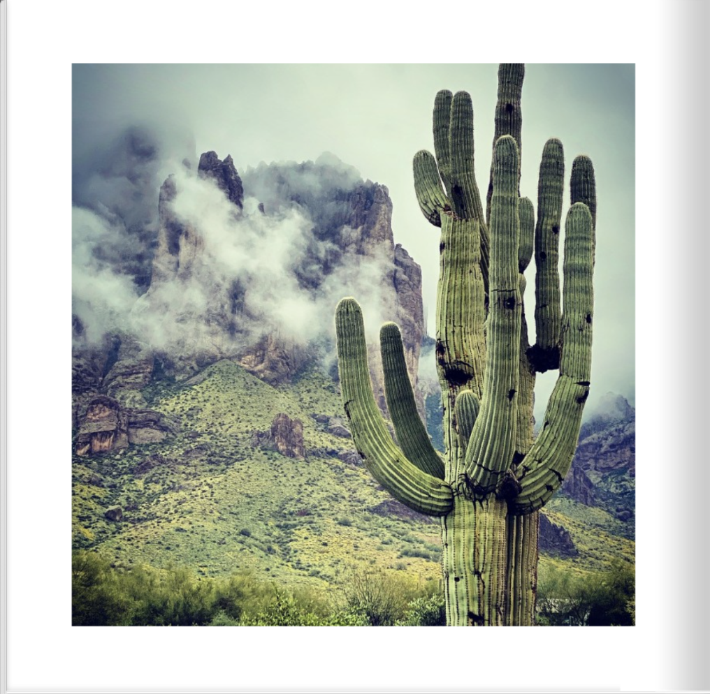
Lost Dutchman State Park, NM
Lost Dutchman State Park is a 320-acre state park located near the Superstition Mountains in central Arizona, and named after the Lost Dutchman's Gold Mine, a famous gold mine legendary among the tales of the Old West. It is accessible about 40 miles east of Phoenix via Highway 60, the Superstition Freeway. The area was first developed as a day use recreation area by the Bureau of Land Management in 1972. The acres abutting the Tonto National Forest was transferred in 1977 via legislative action to the state of Arizona, creating the Lost Dutchman State Park.
Map to General Area

Vol. 1: Pg. 33
Gibbon Falls, Yellowstone National Park, WY
The Gibbon River drops 84 feet to create Gibbon Falls. This fan-type waterfall was discovered in 1872 by members of the second Hayden survey. It appears the falls were named after the river. The falls are located along the Grand Loop Road between Madison and Norris Junctions.
Map to General Area

Vol. 1: Pg. 34
Tucson Mountain Park, NM
Tucson Mountain Park was established April 1929. At approximately 20,000 acres, the park is one of the largest natural resource areas owned and managed by a local government in the U.S. The park has approximately 62 miles of non-motorized shared-use trials. The park’s trails are open to hikers, equestrians, and mountain bikers, and provide a wide range of outstanding experiences, including technical challenges, and breathtaking views. Gates Pass overlook includes interpretive displays and historic structures.
Map to General Area

Vol. 1: Pg. 35
Lake Isabella, CA
The Isabella reservoir offers fishing, boating, water sports, camping, and picnicking. Close proximity to Los Angeles and Bakersfield makes this lake a popular year round vacation spot for southern Californians. The lake is one of the state’s most popular windsurfing areas; reliable afternoon winds, from 35-50 miles an hour, create ideal conditions for intermediate to advanced windsurfers. South Fork Wildlife Area, one of the most extensive riparian woodlands remaining in California, provides fishing, hunting, canoeing, and hiking opportunities.
Jody’s note: Assuming you can avoid the extreme heat and cold temperatures in this area, this is one of my favorite secret jewels to visit. The beautiful and roaring Kern River runs through, which you can follow a great length north toward Sequoia National Forest. There is ample free camping, trails, fishing, historic towns and endless views. You’ll go from desert terrain to big trees in just minutes.

Vol. 1: Pg. 36
Crater Lake, OR
Crater Lake inspires awe. Native Americans witnessed its formation 7,700 years ago, when a violent eruption triggered the collapse of a tall peak. Scientists marvel at its purity: fed by rain and snow, it’s the deepest lake in the USA and one of the most pristine on earth. Artists, photographers, and sightseers gaze in wonder at its blue water and stunning setting atop the Cascade Mountain Range.
Map to General Area

Vol. 1: Pg. 37
Blackrock, CA
This area of rural Inyo County hosts a rest area off highway 395 and spectacular views of the Eastern Sierra Nevadas in California.

Vol. 1: Pg. 38
Catalina State Park, NM
Catalina State Park sits at the base of the majestic Santa Catalina Mountains. The park is a haven for desert plants and wildlife and nearly 5,000 saguaros. The 5,500 acres of foothills, canyons and streams invites camping, picnicking and bird watching — more than 150 species of birds call the park home. The park provides miles of equestrian, birding, hiking, and biking trails which wind through the park and into the Coronado National Forest at elevations near 3,000 feet. The park is located within minutes of the Tucson metropolitan area. This scenic desert park also offers equestrian trails and an equestrian center provides a staging area for trail riders with plenty of trailer parking. Bring along your curiosity and your sense of adventure as you take in the beautiful mountain backdrop, desert wildflowers, cacti and wildlife.
Map to General Area

Vol. 1: Pg. 39
Christmas Tree Pass, NV
Christmas Tree Pass is a pass that leads over the Newberry Mountains in southern Nevada. The road that crosses the pass is called, appropriately enough, Christmas Tree Pass Road. The road begins just outside the town of Laughlin off of NV Highway 163, and ends to the south of the tiny town of Searchlight, NV, on highway 93. This scenic drive is twelve miles in length. The road itself is gravel and is generally in good condition. However, in a few places the road can be a bit rough and steep, particularly right below the pass on the eastern side. Although some careful and slow driving will allow a passenger car to traverse the occasional deep ruts and holes that form here—a high clearance vehicle can be quite helpful. The trip over Christmas Tree Pass is very enjoyable. You get some fine views of the Colorado River valley down below, where Laughlin is located. And you get sweeping views into Arizona. And once you reach the western side of the pass…the sprawling Mojave Desert just goes on and on.
Map to General Area
Vol. 1: Pg. 40
Oracle, AZ
Buffalo Bill Cody owned the High Jinks Gold Mine in Oracle briefly and, in 1911, appeared as "Santa" for a group of local children. The community is the location of the Biosphere 2 experiment. Tour one of the world's most unique facilities dedicated to the research and understanding of global scientific issues. The Biosphere 2 facility serves as a laboratory for controlled scientific studies, an arena for scientific discovery and discussion, and a far-reaching provider of public education. Its mission is to serve as a center for research, outreach, teaching and life-long learning about Earth, its living systems, and its place in the universe; to catalyze interdisciplinary thinking and understanding about Earth and its future; to be an adaptive tool for Earth education and outreach to industry, government, and the public; and to distill issues related to Earth systems planning and management for use by policymakers, students and the public.
Map to General Area

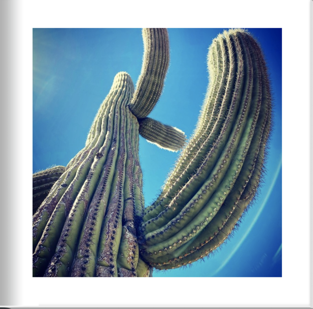
Vol. 1: Pg. 41
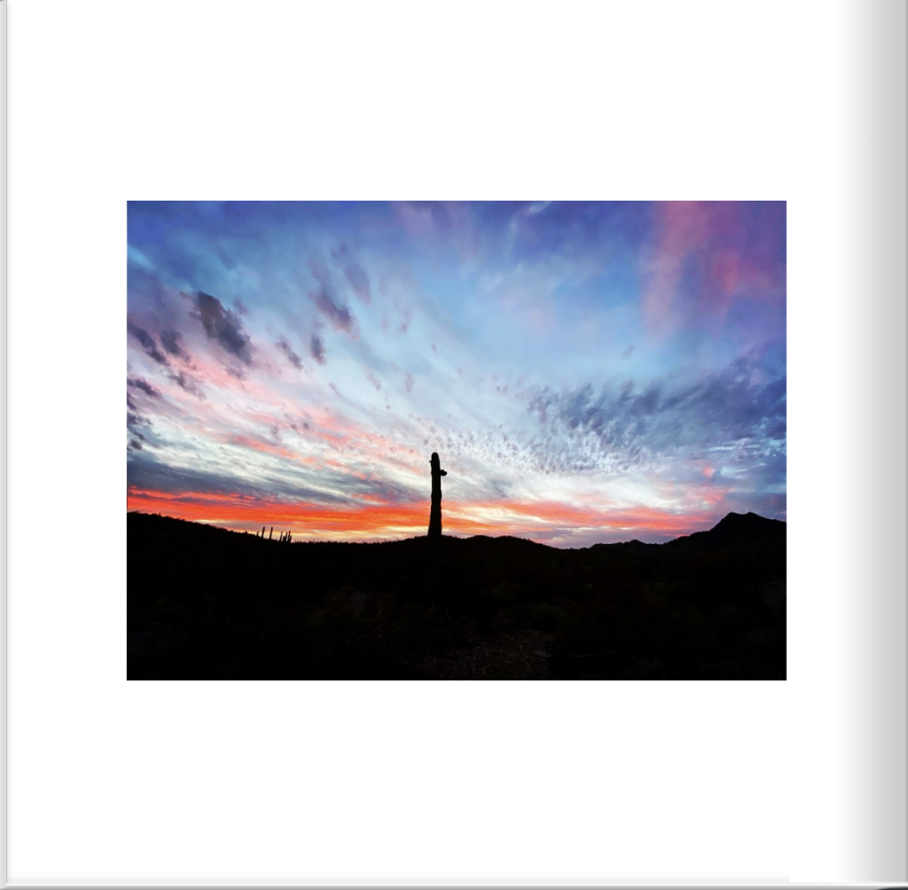
Saguaro National Park, AZ
Tucson, Arizona is home to the nation's largest cacti. The giant saguaro is the universal symbol of the American west. These majestic plants, found only in a small portion of the United States, are protected by Saguaro National Park, to the east and west of the modern city of Tucson. Here you have a chance to see these enormous cacti, silhouetted by the beauty of a magnificent desert sunset.
Map to General Area

Vol. 1: Pg. 42
Yellowstone National Park, WY
On March 1, 1872, Yellowstone became the first national park for all to enjoy the unique hydrothermal and geologic wonders. While the hydrothermal features of Yellowstone continue boiling, steaming, and erupting in winter, life within the park must adapt to the seasonal changes. Yellowstone provides summer range for an estimated 10,000–20,000 elk (Cervus canadensis) from six to seven herds, most of which winter at lower elevations outside the park. These herds provide visitor enjoyment as well as revenue to local economies through hunting outside the park. As Yellowstone’s most abundant ungulate, elk comprise approximately 85% of winter wolf kills and are an important food for bears, mountain lions, and at least 12 scavenger species, including bald eagles and coyotes. Competition with elk can influence the diet, habitat selection, and demography of bighorn sheep, bison, moose, mule deer, and pronghorn. Elk browsing and nitrogen deposition can affect vegetative production, soil fertility, and plant diversity. Thus, changes in elk abundance over space and time can alter plant and animal communities in Yellowstone.
Map to General Area
Vol. 1: Pg. 43
Bodega Bay, CA
Until the Fall of 1775, the Miwok and Pomo Indians lived peacefully in the coastal mountains and valleys of what we now call Sonoma County. Their lifestyle revolved around the seasons, hunting and gathering from the land and harvesting the sea and rivers. Little changed over hundreds of years until the first white sails were spotted off the coast. One of the later settlers was Captain Stephen Smith who married a Peruvian, Manuela Torres, and became a Mexican citizen in order to receive a land grant. Together they established Rancho Bodega bordered by the Russian River to the north and Estero Americano to the south, a large portion of the Bodega Bay Area. Firman Camelot founded the town of "Bay" in the late 1800s, which later changed its name to Bodega Bay.

Vol. 1: Pg. 44
Santa Rosa, CA
Santa Rosa (Spanish for 'Saint Rose') is a city and the county seat of Sonoma County, in the North Bay region of the Bay Area in California. With 176,753 people, Santa Rosa is the largest city in California's Wine Country and Redwood Coast, as well as the fifth most populous city in the Bay Area after San Jose, San Francisco, Oakland, and Fremont.

Vol. 1: Pg. 45
Lake Isabella, CA
The Isabella reservoir offers fishing, boating, water sports, camping, and picnicking. Close proximity to Los Angeles and Bakersfield makes this lake a popular year round vacation spot for southern Californians. The lake is one of the state’s most popular windsurfing areas; reliable afternoon winds, from 35-50 miles an hour, create ideal conditions for intermediate to advanced windsurfers. South Fork Wildlife Area, one of the most extensive riparian woodlands remaining in California, provides fishing, hunting, canoeing, and hiking opportunities.
Map to General Area

Vol. 1: Pg. 46
Palatki Heritage Site, Sedona, AZ
Sedona is an Arizona desert town near Flagstaff that’s surrounded by red-rock buttes, steep canyon walls and pine forests. It’s noted for its mild climate and vibrant arts community. Uptown Sedona is dense with New Age shops, spas and art galleries. On the town’s outskirts, numerous trailheads access Red Rock State Park, which offers bird-watching, hiking and picnicking spots. The Palatki Heritage Site and its sister site, Honanki, were the largest cliff dwellings of the Red Rock Country between AD 1150 - 1350. They were first described by Dr. Jesse Walter Fewkes, famous turn-of-the century archaeologist from the Smithsonian Institution, who gave them the Hopi names of Honanki (Badger House) and Palatki (Red House). The Hopi, however, have no specific names for these sites.